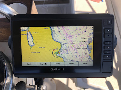
Saying goodbye to my trusty 17 year old Garmin 178C chartplotter/sounder was hard. It's never failed, short of the weird, intermittent and very infrequent GPS scrambles (I blame on the Navy). But when the GPS can no longer connect to the satellite constellations, you know it's time to move on.
The root issue is Garmin is no longer updating the software on my old device and don't offer any viable Apple solutions for getting a the third-party supported upgrade. Planned obsolescence? Moving on!
I started my search by researching Raspberry Pi, upgrading my iNavX and Navionics on my iPad/iPhone. I then decided I wanted a waterproof, sunlight readable device at the helm. Since Garmin bought Navionics and Active Captain in 2017, I figured the advantages of sharing maps and data under one manufacturer might be best in the long run.


The new Garmin ECHOmap UHD 74CV will (supposedly) connect to my Raymarine Evolution EV-100 Wheel Autopilot and steer to multiple waypoints. It has capabilities to allow me to connect to AIS, DSC, sonar, Panoptix, temperature/speed, engine guages, tank levels, and leverage it's wifi capabilities to make updates via Active Captain.
AUTOPILOT (work in progress)
NMEA 2000 network is in place and all components now 'see' each other. The Garmin ertified installer says all I need to do is set a waypoint on the chartplotter then engage the autopilot, once, then hit another confirmation button. This last step has me stumped!
The Garmin manual says "From the Autopilot screen, select MENU > Engage Heading Hold or MENU > Engage Circle. Your intended heading shows in the center of the Autopilot screen." This assumes a Garmin autopilot so not much help there.
I'll likely need to call Garmin (again) on a weekday from 7-7 CST at 1 (800) 800-1020.
This should be easy but lots of folks have struggled with Garmin to Raymarine Autopilot issues. Might have to try disconnecting components of the network or "ignore the data selection section andchoose TRACK the autopilot and GPS communicate". Might need to update the P70 software, currently at v2.17, to get the TRACK function.
Both Garmin and Raymarine run NMEA 2000 networks but with their own proprietary connections. Raymarine uses Seatalk NG. I'm told my Autopilot is new enough that I won't have these issues. It seems like the fluxgate compass may fight with the GPS for steering control. Time will tell!
Raymarine Seatalk color-coded cables: Backbone cables, plugs, sockets and terminators are coded blue. Spur cables, plugs, and sockets are coded white. SeaTalk to SeaTalk NG converter cables, plugs and sockets are coded yellow. SeaTalk NG power cables are coded red.
TRANSDUCER
The ECHOmap came with a transome mounted w/GT24UHD-TM Transducer which is cool for a powerboat, but not great with the healing on a sailboat. I mounted it temporarily on a post of the stern, just to see what CHIRP is all about.
I connected my old P79 in‑hull transducer but unfortunately, age has also degraded the P79, and it does not perform to spec. It functions well in shallower depths below 150ft (when you need it) but not so well in deep water. I have purchased a Garmin GT15M-IH Transducer which resolved the deep water issue and upgraded me to CHIRP technology.
(Airmar phone tech support had suggested I upgrade to a P75, so I could re-use my in-hull housing and step up to CHIRP technology.) I could not confirm that it would work with Garmin, and it cost a bit more than the GT15M, so I didn't take the chance.
To connect to my old P79, I purchased a C1225 cable which has the sounder port connection and a small box to connect the wires from the sounder. I hope to keep this connected and plug the Garmin GT15M-IH into my NMEA 2000 backbone.
DIGITAL SELECTIVE CALLING (DSC) (work in progress)
Standard Horizon Intrepid VHF Radio will need to receive GPS data on the Blue wire. This is an input to the radio. Connect the TX(+), Data Out wire of the Garmin. Usually Blue on Garmin.
The Green and Brown wires should be attached to TX (-), RX (-) and or ground. Connect this to the black ground wire or (-) wires on the Garmin. Usually Black on Garmin.
The output of DSC data will occur on the Gray wire at 4800 speed. Output leaving the radio. Connect this to the RX(+), Data In Garmin wire. Usually Brown on Garmin.


Instructions:
- Garmin ECHOmap UHD 74CV
- Garmin ECHOmap UHD Software Updates (updated 03/12/2023)
- Garmin Support Center
- Garmin Owners Manual
- Garmin Installation Manual
- Active Captain Community
- Install Instructions for GSD 24 Transducer Adapter
- Garmin Power and Data Cable
- Raymarine Evolution Autopilot System Pack - EV-100 Sail
- Raymarine Seatalk Components
- Raymarine Seatalk Diagram
- Raymarine P70 Controller Software Updates
- P70 Controller Manual
- Airmar compatibility chart
- Airmar P75 Transducer
- Airmar P75 Installation
Cables Used:
- SeaTalk NG 5 Way Connector
- SeaTalk NG Spur Cable, 3m & .4m
- SeaTalk NG to DeviceNet (NMEA2000) Adapter Cable, Male
- GARMIN–2 Meter NMEA 2000 Backbone/Drop Cable
- GARMIN–6-pin Transducer to 8-pin Sounder Wire Block Adapter
- NMEA 2000 T-connector
Charts:
- BlueChart g3 Vision for Canada, Puget Sound and Dixon Passage (Rebate)
- BlueChart g3 for U.S.

